Les hauts de la Maladène
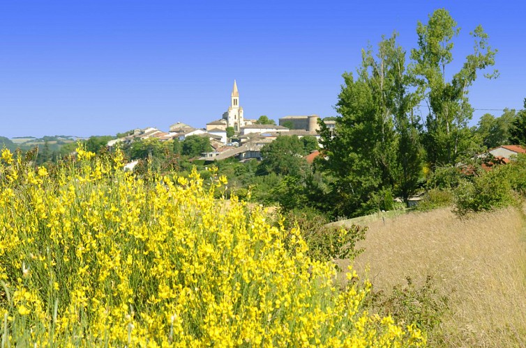
Salvagnac, an ancient fortified village, offers several discoveries: the castle towers (14th-15th centuries), the Notre-Dame church with its treasury of sacred art including a processional cross from 1514, and frescoes by Nicolaï Greschny (mid-20th century).
In this region of cultivated lands, preference is given to traditional cereals, especially wheat. Grown on the hillsides of the Tarn, it provides millers with pure flour used in making "Lo Cantél"; a recipe based on artisanal practices resulting in a soft bread with a crispy crust and a creamy, melting interior.
Description
- From the parking lot at Les Sourigous leisure base, cross the footbridge and continue straight on the grassy path for 150 meters.
- Turn right onto the road (follow the GR de Pays, marked with yellow and red signs). At the intersection, continue straight on the grassy path between the fields.
- Turn left onto the road (ignore the yellow and red markings). At La Tounario, turn right, then descend left onto the dirt path. At the intersection, turn right.
- Take the road to the right to reach Les Barrières. After the water tower, turn left and continue straight on the road. Take the gravel path on the left.
- At the crossroads, take the trail into the woods on the left. Descend along the fence.
- At the crossroads, continue straight, then turn left and cross the Tescounet stream.
- Turn left again. At the intersection, continue straight on the track "GR de Pays" (yellow and red markings). On the road, turn left for about 350 meters. Turn left again. After the bend, descend to the right towards "Les Camalets". Turn right and continue straight. Turn right onto the road for about 50 meters.
- Descend again to the right onto the path. Take the road to the left. At the crossroads, turn left.
- Turn right to return to the starting point
- Departure : Base de loisirs les Sourigous, at the foot of Salvagnac
- Arrival : Same place as the start
- Towns crossed : Salvagnac, Lisle-sur-Tarn, and Puycelsi
Forecast
Altimetric profile
Recommandations
Information desks
Place de la libération, 81600 Gaillac
Place Paul Saissac, 81310 Lisle-sur-Tarn
Hôtel de la Fite - 2 rue Amédée Clausade, 81800 Rabastens
Transport
By bus: line 721 (Albi - Montauban) - St Pierre stop 500m from the starting point.
More information on liO-occitanie
Access and parking
20 km west of Gaillac via the D999.
12 km north of Rabastens via the D2.
Do not go all the way to Salvagnac, but stay on the D999 towards the Les Sourigous leisure base.
Parking :
Accessibility
- Emergency number :
- 114
Report a problem or an error
If you have found an error on this page or if you have noticed any problems during your hike, please report them to us here: