Chemin de Dame Fines
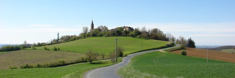
The village was founded in 1246 by Dame Fines Alaman on the site of the Castel de Puech Buégo, which means "hill (puech) of Bégon." Its strategic location, which allowed for the monitoring of passageways, and the village's economic development aroused the envy of many lords.
Three points of interest mark the route: the Saint-Martin de Grizac chapel, now desacralized (point 4); the Saint-Sigismond hill, which overlooks Briatexte and the Dadou Valley with a magnificent viewpoint (point 5); and finally, the Saint-Cécile de Mouribal chapel, dating from the 16th century, near the commune of Busque (point 7).
Description
- At the bottom of the village, descend the stairs. At the end, turn left and then right onto a grassy path. Continue straight down. After the stream, the path turns left. Follow it to reach a lake.
- Go around the lake. At the second angle of the lake, descend to the right via discreet steps. Cross the stream and then ascend left on the path. Follow it until you exit the woods. Climb up the path directly in front. Ignore the first path on the right and turn onto the second, which leads to the road.
- Turn right. At the road junction, head right towards Jamblanc. Higher up, the road becomes a path. At the road, go left. Before the road junction, turn right onto the path. This leads to the Saint-Martin de Grizac chapel.
- At the cemetery corner, turn left. At the bottom of the road, turn left. Further along, follow the sign to Puybegon to reach the road junction from the outward route. Ignore Jamblanc. After 350 meters, ascend right onto the dirt path. It passes below the Saint-Sigismond chapel. At the tarmac, descend left.
- At the road, turn right. Further on, take the dead-end path. Before Mondelié, turn left onto the grassy path. At the RD, turn left. At the next intersection, turn right towards Le Moulin. Cross the bridge and continue straight to reach a road junction.
- Leave Gravelle to the left and a road to the right to continue straight. Further on, turn left towards Borie Nove. Leave the road for a path. After 250 meters, enter the woods on the left via a discreet path to reach the Sainte-Cécile de Mouribal chapel.
- Continue along the path and then, on the road, turn left. Descend the road to the junction (point 6), turn right on the road, go 200 meters, then turn right at the fork.
- Stay on the road until you reach the village.
- Departure : On the D15 road (50 meters below the Puybegon town hall) - Hiking departure sign
- Arrival : Same place as the start
- Towns crossed : Puybegon
Forecast
Altimetric profile
Recommandations
Information desks
Place de la libération, 81600 Gaillac
rue Saint-Jean, 81300 Graulhet
Access and parking
15 km south of Gaillac via the D87, then in Montans, take the D15 towards Briatexte.
12 km northwest of Graulhet via the D631, then in Briatexte, take the D15 towards Puybegon-Peyroles-Gaillac.
5 km north of Briatexte.
Parking :
Report a problem or an error
If you have found an error on this page or if you have noticed any problems during your hike, please report them to us here: